Papua New Guinea Provinces
NEW IRELAND PROVINCE
 Long, narrow and mountainous, New Ireland boasts undeniable
beauty, peaceful people, never ending beaches,
the popular Malagan show, the unique annual
Shark Calling festival, game fishing and
a history visited by explorers, missionaries,
traders and Japanese armed forces. Long, narrow and mountainous, New Ireland boasts undeniable
beauty, peaceful people, never ending beaches,
the popular Malagan show, the unique annual
Shark Calling festival, game fishing and
a history visited by explorers, missionaries,
traders and Japanese armed forces.
Discovered by Dutch explorers in 1516,
it was 1877 when the first missionaries
arrived. With the development of copra plantations
it soon became one of Germanys most profitable
colonies. During World War 2, New Ireland
fell to the Japanese and many of the islands
towns, infrastructure and industry was destroyed.
New Ireland was also the setting for the
saga of the Marquis de Ray who advertised
Cape Breton as a thriving settlement, sold
hundred of hectares of land to gullible
settlers who were dumped with three weeks
supplies, including a mill, note books and
bricks, into a tangled jungle, with perpetual
rainfall and unfriendly neighbours. Most
died of starvation or malaria before being
rescued and sent to Australia. Parts of
the grinding stone for the never used grain
mill can still be found in Kavieng. As for
the Marquis de Ray, he ended his days in
a lunatic asylum in France.
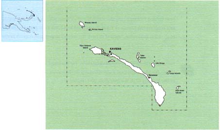
The provincial centre of Kavieng is situated
at the northern tip of the island. It has
often been described as a "typical
Somerset Maughan south sea island port".
It has a large, beautiful harbour and is
a popular destination for game fishing enthusiasts.
Along the edge of the harbour is Kaviengs
Harbour Drive, a gently curve road, shaded
by huge trees, which passes many points
of historical interest. A couple of kilometres
out of Kavieng, along the Buluminski Highway,
a little pathway leads off the road to a
limestone cave filled with crystal clear
water. At Utu village, the high school has
a small museum with exhibitions of Malagan
carvings - carved totem-like poles used
in initiation ceremonies and rituals; ancient
stone tools and vessels and a shark catching
propellor.
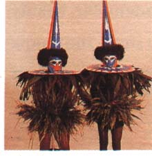
New Ireland is the centre for the art of
shark calling. Certain men have the ability
to "call up" sharks. The unfortunate
shark swims up to the callers boat where
they can be speared and netted. Alternatively
the shark propeller is used - a noose is
hung with half coconut shells which make
a rattling noise, attracting the shark up
through the noose. A rope attached to the
noose is connected to a wooden propeller
which is spun round to tighten the noose
and simultaneously pull in the rope. The
shark, unable to keep moving, effectively
drowns.
New Ireland Province includes a number
of offshore islands. From the northeast
coast are the islands of Tabar, Tanga, Feni
and Lihir. Lihir Island is the site of the
Lihir gold mine, reputed to have the second
largest gold deposit in the world.
Kavieng has three hotels, the Kavieng Hotel,
the Kavieng Club and the Malagan Lodge.
Freshly caught local seafood features on
the menus of all hotels. Adjacent to the
Kavieng Club is a nine-hole gold course.
Map of New Ireland
NORTH
SOLOMONS PROVINCE
 North Solomons Province has two main islands,
Burka and Bougainville plus a scattering
of smaller islands and atolls. It is located
north east of mainland Papua New Guinea.
North Solomons Province has two main islands,
Burka and Bougainville plus a scattering
of smaller islands and atolls. It is located
north east of mainland Papua New Guinea.
A decade ago, North Solomon Province was
the most frequently visited destination
in Paua New Guinea. Its natural beauty and
friendly people presented the perfect ingredients
for an idyllic tropical island holiday.
However during the last few years, internal
conflicts have temporarily suspended services
to the province and it is currently closed
to tourism.
Map of North Solomons
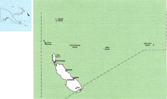
ORO PROVINCE
 Few people would expect
to find fjords in Papua New Guinea. The
Tufi area on the south east coast of Oro
Province is one of PNGs best kept secrets.
Situated on Cape Nelson, Tufi is a spectacular
place to visit. Few people would expect
to find fjords in Papua New Guinea. The
Tufi area on the south east coast of Oro
Province is one of PNGs best kept secrets.
Situated on Cape Nelson, Tufi is a spectacular
place to visit.
Cape Nelson, jutting out into the Solomon
Sea, was formed by the eruption of three
volcanoes, whose fast flowing lava created
the rias, or fjords. Unlike the fjords of
Scandinavia, the water is always warm and
the sheltered bays are home to stunning
coral formations and tropical marine life.
The fjords are over 90 metres deep and
rise vertically out of the water to over
150 metres. Wide entrances are protected
by reefs and they funnel into the mountainside
where mangroves form a canopy over narrow
waterways. The vertical faces of the gorge
are covered with moss and orchids and waterfalls
cascade directly into the sea.
Although the main attraction is diving,
there are plenty of options at Tufi - bushwalking,
deep sea fishing, windsurfing, swimming,
canoe trips or just lazing on the white
sandy beaches.
Wander among the villages or go to the
open market and see the handcrafted pottery,
jewellery and tapa cloth that are typical
of the region. Tapa cloth is made from the
beaten bark of the paper mulberry tree and
decorated with exotic designs in natural
earth colours. In October every year there
is a Tapa Cloth Festival. Other festivals
held locally are Martyrs Day and the Korata
Church Day. The province is also the home
of the largest butterfly in the world, the
Queen Alexandra Birdwing, which as a wingspan
of 30cm. With the diminishing rainforest,
this species is unfortunately fast becoming
extinct.
There are a number of village guest houses
which offer comfortable accommodation and
will arrange fishing, diving and coral viewing
excursions. The Tufi Dive Resort, perched
on the side of a fjord has mountain views
up and out to sea. It is constructed of
bush materials and decorated with carvings
and artefacts from around the country.
Oro Province has a history of drama, from
the early gold rush days to the devastating
Pacific campaign of World War 2. The northern
end of the Kokoda Trail terminates at the
village of Kokoda and from here to the coast,
and around the beaches of Buna and Gona,
some of the most violent and bitter fighting
of World War 2 took place. It is estimated
that over 15,000 Japanese soldiers died
on the Kokoda Track. The area is still littered
with war relics and at Jiropa Plantation
on the Buna Road, there is a Japanese plaque
commemorating their dead.
Not long after the war Mt Lamington erupted,
wiping out the district headquarters at
Higaturu and killing nearly 3,000 people.
Today the provincial capital is located
a safe distance from the volcano, at Popondetta.
Mt Lamington is a favourite climb for bushwalkers.
There are road links between Popondetta,
Tufi, Ioma, Kira, Kokoda and Afore with
PMV buses travelling regularly between the
districts. Oro Province is served by Air
Niugini, MBA and other third level airlines,
with flights to Popondetta and Tufi.
Map of Oro

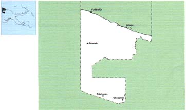
SANDAUN
PROVINCE (WEST SEPIK)
 Vanimo, the capital
of Sandaun Province, sits on a neat little
peninsula with beautiful beaches on either
side. A pleasant walk around the headland
brings the snorkelling enthusiast to several
good spots. To the west, wade past vine
draped limestone headlands to reach the
final resting place of a rusted Japanese
landing barge. Vanimo, the capital
of Sandaun Province, sits on a neat little
peninsula with beautiful beaches on either
side. A pleasant walk around the headland
brings the snorkelling enthusiast to several
good spots. To the west, wade past vine
draped limestone headlands to reach the
final resting place of a rusted Japanese
landing barge.
Vanimo, 30 kilometres from the Indonesian
border is PNGs entry port from Jayapura
in Irian Jaya (formerly West Papua). This
area of the world has seen little development
in international tourism, other than visitors
enroute from Irian Jaya to other parts of
Papua New Guinea, or the intrepid traveller
or surfer in search of the perfect wave.
Superb beaches west of Vanimo, towards
Wutung, attract surf board riders from PNG
and overseas during the months of September
to January. The 260 kilometre shoreline
is pounded by heavy seas caused by the blustery
north west winds during December to March.
However safe all-year round anchorage can
be had in Vanimo. Several little islands
lie offshore from the town of Aitape, the
only other town in Sandaun Province.
Aitape was established as a station by
the Germans in 1905 and was occupied by
the Japanese during World War 2. Bits of
aircraft wreckage can be found near the
wartime Tadji airstrip and a war memorial
stands nearby.
The headwaters of the Sepik River are in
Sandaun Province. Here the river narrows
into dense, mountainous country and only
small boats can navigate upstream from the
village of Ambunti. There are no roads in
the Upper Sepik and much of the province
is covered in rainforest.
The villages here are known for their specialist
religious cults. The people of Maio and
Yessan have a yam cult and the isolated
villages of Swagup is the home of the insect
people, whose art form incorporates the
figures of the sago beetle, dragonfly, praying
mantis and other insects.
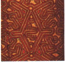
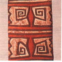
Among the distinctive artefacts from Sandaun
are painted canoes of Sissano Lagoon and
large shields from the Telefomin district.
The shields have broad zigzag, spiral or
V designs that represent their ancestors
bodies.
Vanimo has three hotels the largest of
which is the Sandaun Motel. In other parts
of the Province village accommodation is
available and some mission stations also
offer simple accommodation.
Air Niugini flies to Vanimo weekly enroute
to Jayapura, Irian Jaya.
Map of Sandaun
SIMBU
PROVINCE
 In the heart of the Highlands
is Simbu Province, bordered by Madang to
the north and the Gulf country to the south.
It is the smallest but most densely populated
of all the provinces. The terrain is extremely
rugged, with many of the valleys inaccessible.
Some of the highest mountains in Papua New
Guinea are in Simbu Province including Mt
Wilhelm, at 4,509 metres, the highest peak
in Papu New Guinea. In the heart of the Highlands
is Simbu Province, bordered by Madang to
the north and the Gulf country to the south.
It is the smallest but most densely populated
of all the provinces. The terrain is extremely
rugged, with many of the valleys inaccessible.
Some of the highest mountains in Papua New
Guinea are in Simbu Province including Mt
Wilhelm, at 4,509 metres, the highest peak
in Papu New Guinea.
Known to avid mountain climbers around
the world, for the reasonably fit it is
not a difficult climb for those who like
to be physically challenged. There is a
clearly marked track which passes traditional
Simbu villages, through dense rainforest,
into the valley before reaching Pindaunde
Lakes where there are basic huts for overnight
stays. The view from the summit is spectacular,
on a clear day stretching from the north
to the south coast. Cold weather gear is
recommended as it can get very cold on top,
sometimes snowing. Guides and porters can
be arranged as well as organised trekking
expeditions. A trout and rabbit farm at
the base of the mountain has a guest house
with easy walking tracks nearby.
Kundiawa, the provincial headquarters is
set in picturesque surrounding beside a
spectacular airstrip built on a sloping
ridge beneath the towering mountains. Kundiawa
is not a tourist attraction in itself but
a stepping stone for mountain and river
adventures in other parts of Simbu Province.
Only a few kilometres from Kundiawa, close
to the main road, are the Keu Caves, suitable
for caving expeditions. There are a number
of other caves around the district which
are burial places for the remains of warriors
killed in battle.
The Wahgi River is considered by experts
to be one of the best rafting experiences
in the world as the river rushes through
deep chasms, stretches of rapids, under
small rope bridges and waterfalls. Serious
bushwalkers can follow a four-wheel drive
track down to the coastal town of Madang.
The three or four day walk offers the intrepid
bushwalker some of the best look-out views
in the country.
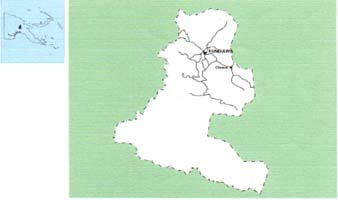
Map of Simbu
|